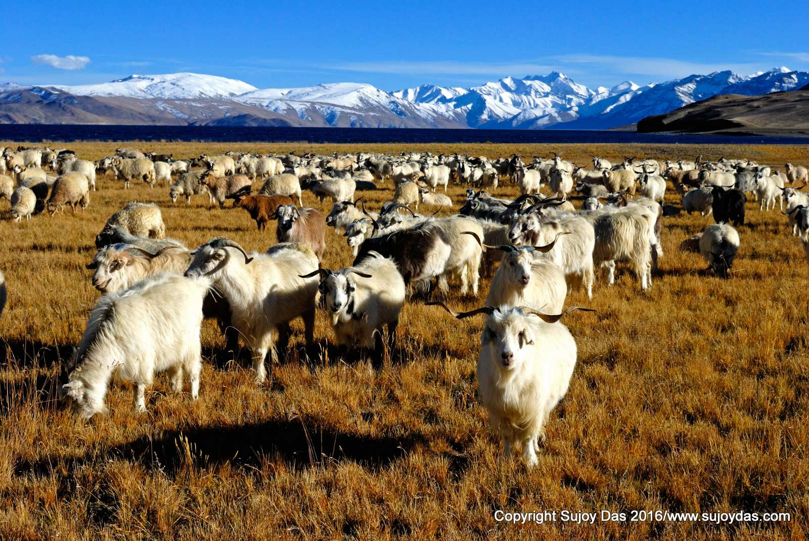
If you are fit and can manage only one trek in Ladakh, I recommend this one. The trails are relatively free of noisy tourists who prefer the great herd at Markha. Here, the rolling, billowing grasslands stretching out as far as the horizon are usually empty, giving one the sense of infinite, almost primordial space. Occassionally you will chance upon a nomad on horseback herding his great lumbering, shaggy yaks. Ranging across the western extension of the high Tibetan or Changthang plateau, the trek starts at over 4000 m at Rumtse, well above that throughout, often peaking over 5000m at the passes. And though this at first may be daunting, once you have acclimatised the walk is surprisingly easy on the legs as the trails— mostly well-defined stone and gravel-free paths— meander gently through velvet-soft pastures. . This area is colder and windier than other treks in Ladakh, so ensure you have a good parka and a warm sleeping bag.
Who should join this trek?
A good choice for regular hill walkers, high level of fitness required. Prior trekking experience is advisable
1) Walking times: average 5 to 8 hours walking per day
2) Altitude: up to 5,450 metres - most of the trek stays above 4000 metres with passes above 5000 metres.
3) Terrain: for some of the time following well-travelled trails although also likely to encounter rough and rocky conditions.
4) Remoteness: the trek is in a remote mountain area and a long distance from the roadhead and the nearest cities. There is no mobile phones and wifi connectivity.
This route description is courtesy Sonia Jabbar
August 30th to September 10th 2017
Day 1: Delhi to Leh by flight
Days 2 and 3: Acclimatisation days in Leh and around.
Day 4 Rumtse-Kyamar (4400m) Time: 4 to 5 hours 9 km Level: Easy
We drive to Rumtse (2hours) , a small village at 4,200 m (14,000 ft), is where your pack horses will meet you to load up for the trek. Walk up the highway from the tea stall and at the sign which points to the Highest Idli-Dosa joint in the world, alas, turn away to the left or east down towards the river. Cross the river at the point where the large rocks form a convenient bridge to the disused jeepable dirt road constructed by the army. Follow east around a small spur and then turn south along a small stream. Walk upstream for about a kilometre and then cross stream, climbing up small plateau. Follow the well-defined path for about an hour which turns east (left) and then runs south-east back towards the stream which you will have to cross. Do not follow the stream as it veers to the east. Continue south along the bottom of a wide, grassy stream-fed valley for 2-3 hours until you come upon a couple of large mani walls. This marks the beginning of Kyamar at 4,400 m (14,600 ft.).
Day 5 Kyamar to Mandalachan 4 hours to Tisaling (4250m) 8 hours 15 km Level: Moderate to Difficult
Follow the jeep track on the eastern edge of the valley which suddenly widens. The road takes a long winding route to get to the Kumur La. But there are short cuts: well-defined pony tracks cutting across the road. A pleasant 2-2.5 hours climb is over a very gentle gradient (except about an hour from the top where the track is a little steeper), will take you to the Kumur pass (5080 m/ 16,764 ft.) marked by cairns and prayer flags. From the top do not head straight down towards the V of the valley. Instead find a path skirting the top of the hill on the right. Forty-five minutes to an hour along this easy path and you will find it curving to the south, or right before zigzagging down to the base of the valley at Mandalachan. You can have lunch here.
The main valley through which the stream runs lies north-south. Cross the stream and find a smaller valley directly in front, or to the east south-east. Walk up the trail for half an hour as it turns east and becomes quite steep. But it is only about another half hour to forty minutes up to the Mandalachan La, 5090 m (16,800 ft.).
Follow the path which skirts the top of the hill on your right, or south. Walk in a south easterly direction for about forty-five minutes until you round a spur and find yourself facing another east-west valley. The path zig-zags down to the floor of the valley where you cross a small stream and either camp there or walk another 15 minutes further south to a larger stream (4250 metres)
Day 6 Tisaling to Ponganagu (4500m) 7 hours 15 km Level: Difficult
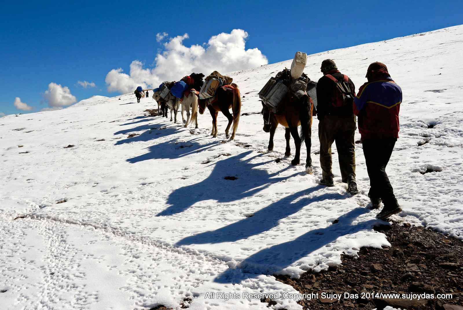
FromTisaling proceed south towards a large hill. Here the path is not as well defined as it was earlier but find a saddle-like dip at the top of the hill which is the Shibuk pass. Running from the bottom to the top in the middle of the hill is a dry nullah. Zig-zag up either to the left or right of this. Watch for Bharal in this area. It takes only about an hour to get to the top which is over 5000 m (16,500 ft.) Once over the pass walk straight down heading south to the bottom of the valley. Walk along the valley which narrows as it turns slightly to the west. Two hours later find a well-sheltered campsite at Shibuk. Either camp for the night or proceed further south following the path which is now visible to Ponganagu on Tso Kar lake.
From Shibuk the valley narrows into a gorge and the path runs along its right side until the gorge opens up onto a vast sandy plain. Follow the track down into the plain. Do not be tempted to walk east around the hill in front towards Tso Kar which will be visible for this is a much longer way. Walk in a south-westerly direction over the top of the hill. The sandy soil makes this hard going. Once at the top you’ll find you’re on a small plateau across which runs a path defined by cairns. Cross the plateau and the path will lead down towards Ponganagu (4500 metres) by Tso Kar. Unfortunately the campsite is dusty and a favourite of tourists from Leh who have 4-wheeled down to the lake.
Day 7: Ponganagu to Riyul Time: 2-3 hours Level: Easy Riyul to Nuruchan (4350m) 4 hours 16 km moderate
If you’re not absolutely dead tired, another two to three hours of easy walking on almost flat motorable road along the right or western edge of the lake will lead you to a large chorten beside lush pasture land which marks the campsite of Riyul. You can have lunch here.
Then, follow the jeep road which runs on the right of the pasture moving south. The road traverses soft, sandy soil which makes the first few hours difficult walking. Some 4x4 have made tracks moving south-east. Do not follow this. Carry on south until you reach the fields of Nuruchan (4350 metres). If you are walking from Ponganagu you may want to camp here. The campsite is further south from the village. The track follows the river upstream, curving to the right.
Day 8 Nuruchan to Gyama Barma (5150m) Time: 7 to 8 hours 16 km Level: Tough
Cross the river at some point upstream. Wherever you cross you will have to take your boots off and wade across the calf-deep waters. Climb onto the other bank and climb up the plateau in front. Walk in a south easterly direction. The path is well defined and climbs very gradually to the top of the Horlam Kunga pass. From Nuruchan it should have taken no more than three to four hours to the top. From the pass follow the path which goes down rapidly to the base of the valley in a south-easterly direction to Rajungkaru. There are many places to camp here. It’s also a favourite with the nomads. Although their camps are picturesque watch out for their large, fierce dogs.
From Rajungkaru, follow the river upstream until you see a rocky plateau with nomad camps. You’ll need to climb up to the plateau, cross the stream and head straight south towards the Kyamayuri La 5410 m (17,853 ft.). Do not head towards the south west which leads over the Barma Pass. Instead, follow the well-defined track, keeping to the left or east side of the mountain. The last hour is difficult as the track becomes steep and the soil is soft and crumbling. It often snows on this pass so keep a jacket handy. From the top follow the track which runs along the left or east side of the mountain down to a vast, grassy valley ringed by snow peaks on the south west. A river runs east-west. Either camp here at Gyama Barma for the night or if you aren’t knackered then continue upstream until the track moves south east up a rocky mountain. You will have to cross the stream to get to this.
Day 9 Gyama Barma to Gyama (5100m) 3 to 4 hours 9 km Level: Moderate
From Gyama Barma it is a steep one hour climb up to Kartse La which is again well over 5000 m. From the top the path runs down a meadow gradually reaching the bottom of the hill at Gyama after another hour or two.. There are two streams here. A small stream running west-east (right-left) and a larger one running southwest-northeast. Camp along the small stream as it is well sheltered. The larger stream runs through a windy plain which would get cold at night.
Day 10 Gyama to Korzok (4500m) Time: 6-7 hours 14 km Level: Moderate to Difficult
At Gyama cross the large southwest-northeast stream which will take you to the eastern side of the valley. The pony track which runs below the Mani wall on the left leads south-east up a smaller valley. Climb steadily for a couple of hours, traversing a small grassy plain and then entering a narrow gorge. You will need to criss cross the shallow stream in the gorge at several points. When the gorge opens up again find the path turning left or east over a grassy knoll until you come upon the prayer flags and cairns marking the Yalung Nyau La. From Gyama this would have taken about three hours. You can catch a glimpse of Tso Moriri from the pass. The track moves down steeply towards the east onto a broad, dry plain, eventually turning into a small pleasant green valley traversed by a stream. This area provides excellent campsites. A little further down towards Korzok and you will again run into campers from Leh who have made the journey to Tso Moriri by jeep.
Tip: Check out the Gompa at Korzok which houses a tooth relic of Kashyapa Buddha in the Heart Chakra of the Buddha statue in the main prayer hall.
Day 11: Tso Moriri to Leh by road Time: 6 hours
Day 12: Leh to Delhi by flight
August 30th to to September 10th 2017
The cost of the trek is Rs 80,000 /- for Indians (US $ 1450 for foreign passports ) Leh to Leh plus taxes. - some exclusions apply. Service Tax @ 4.50% is charged extra. In the event of GST being implemented from 1.4.16 applicable GST rates will be charged instead of Service Tax.
The cost per person for Leh to Leh (12 days ) as per the itinerary given earlier
Costs given above are at current rates of 2016 and may change without notice as by 2016 we may have further rupee devaluation against the dollar. Changes if any will be notified 3 months before the trek.
Costs include:
Transfer by four wheel drive vehicle from Leh to Rumtse ( start of trek) and pickup from Tso Moriri to Leh at the end of the trek.
One day monastery visits around Leh – Shey, Thikse, Hemis etc. on day 2 in a private vehicle
Four nights accommodation in Leh on twin sharing basis in a good standard hotel.
All accommodation in tents and meals on trek for seven days ( day 4 to day 11) as per itinerary; breakfast, lunch and dinner.
Cost of guides/cook/helper/ponyman and ponies as needed for the trek.
Costs not included
Flight Costs from home country to Leh and back.
All meals in Leh not covered.
Airport taxes if any.
Client travel and medical insurance of any kind. Emergency evacuation costs if needed.
Bottled drinks; boiled, filtered or bottled water; alcohol; snacks etc
Personal clothing and equipment; sleeping bag; duvet /down/ goretek jacket, medicines for personal use etc.
Tips to guides/cook/helper/ponyman at the end of trek
Air Tickets
Present cost of air ticket Delhi – Leh – Delhi ranges between Indian Rs 12,000 to Rs 18,000 return. Early bookings will attract lower fares. Some airlines flying to Leh from Delhi are Jet Airways, Air India and Go Air.
| ITEMS | REMARKS | |
| Duffle Bag | All the equipment listed below other than what you need for the day should be packed into a duffle bag, locked and handed over to the porters in the morning. In case you cannot get a duffle bag in your home country these are available very cheap in Kathmandu and I can help you with this. The duffle bag should not weight more than 10 kgs! | |
| 1 | Sleeping Bag | Warm sleeping bag is needed at least three season rated to 15F |
| 2 | Daypack or Hipbelt | To carry water, one jacket some nuts, chocolates, cap, camera to keep with you in the day, maybe gloves and cap as well, hiking poles etc. |
| 3 | Boots or Trekking Shoes | one pair |
| 4 | Slippers or Sandals for camp | lightweight to wear in the evenings |
| 5 | warm Socks | 2 pairs to carry and one pair to wear |
| 6 | Gloves | one pair |
| 7 | Underwear | 1 to wear and 2 to carry |
| 8 | Warm Cap | one- Wool or fleece is usually good |
| 9 | Heavy jacket | the warmest you can get as nights and early mornings are cold - down is usually preferred otherwise a warm synthetic filled jacket. |
| 10 | Thermal Underwear ( top and bottom) - long johns | inner layer to wear at night and early morning ; |
| 11 | Mid Layer | Usually a jacket of fleece or wool which can be worn over a thermal layer or by itself while walking |
| 12 | T shirts for walking | one to wear and 2 to carry - if the sun is hot you can walk in a T shirt |
| 13 | Trousers /tights etc | one to wear and one to carry light weight preferred |
| 14 | One Rain Jacket /Wind Jacket/Soft Shell jacket | useful in case of wind ... you may need it in light rain though we would usually take shelter and wait for the rain to stop. Our trek is not in the rainy season though some light rain/snow in the late afternoon evenings cannot be ruled out. |
| 15 | Torch or headlamp | one small needed carry one set spare batteries |
| 16 | Sun bloc | one small tube should be ok spf 30 or 50 |
| 17 | some essential medicines | vitamins, headache, fever, pain killers, diamox for altitude, your own specific medicines etc |
| 18 | Hiking poles | if you have bad knees then this is recommended especially on the down hills!! |
| 19 | Water bottle | one no 500 ml or 1 litre is ok you can use the 500 or 600 ml empty coke or pepis bottles |
| 20 | Sun glasses | the sun is strong in the day |
| 21 | Cap for the sun | ditto! |
| 22 | small towel | for baths and wash up in case you can use the hot shower |
| 23 | toothbrush, paste, soap, shampoo, vaseline, comb | and any other toilet items you may need! |
| 24 | wet tissues - wet ones for bathroom | called wet ones in India |
| 25 | some washing powder surf etc small | to wash clothes en route if needed |
| 26 | Nuts, raisins etc all mixed up | can be divided into small packets for daily use |
| 27 | Chocolates /Energy Bars/Amul cheese slices/tea bags | Carry some chocolates or energy bars to have on the way. Amul cheese slices are very useful and can be had as snacks when you are tired of sweets! |
| 28 | Sweets | for energy |
| 29 | Volini gel/ Bengay etc for aches and pains | or any other equivalent |
| 30 | Iodine or chlorine tablets for water purification | available in Kathmandu- this is important as mineral water bottles are expensive; for overseas visitors you can get iodine tablets in REI and other large outdoor outlets |
| 31 | Electral or any other rehydating salts | Carry a few small packets of electrolyte - useful to have mixed with water if dehydrated |
| 32 | some spare plastic bags to pack wet stuff, dirty clothes etc | |
| 33 | Book in case you want to read on the way and IPOd for music optional! | |
| 34 | Two small locks one for your duffle bag and one for your room in case the lodge does not have a lock | |
| 35 | Clothes line with hooks on either side in case you want to hang up your wet clothes to dry outside!! | |
| 36 | Super Glue | To patch up boots that may give way! |
| 37 | Face mask | For dust, cold winds etc available in kathmandu |
| 38 | Extra shoe laces | one pair |
| 39 | Binoculars | |
CANCELLATION CHARGES
If it becomes necessary to cancel your tour, you must notify South Col Expeditions immediately in writing by email or letter. Once we receive your notice, cancellation will take effect. Please note that the following charges will apply on cancellation:
• if cancellation takes place more than 45 days prior to departure, your full deposit will be returned except a processing charge equivalent of 5% of trip cost, excluding the service tax component
• if cancellation takes place between 45 and 30 days prior to departure, 50% of the tour price will be forfeited
• if cancellation takes place less than 30 days prior to departure, 100% of the tour price will be forfeited.
The tour price is quoted as a package. No partial refunds or credit will be given for services not used. We recommend that you obtain cancellation travel insurance upon booking. If you can replace your spot by getting someone else to take that seat cancellation charges would be waived completely and you would only be charged the processing fee of 5%.
IN CASE OF LEAVING THE GROUP
If due to illness or any other reason a client has to leave the group and go down or wait at a lodge for the group to pick him/her up on the way back or return to Leh, all expenses including lodging, fooding, transport and any porter/guide related expenses if any are to be borne by the individual client over and above the trek fees paid for the trek. There are also no refunds for leaving a trek before completion.
HIRING OF PONIES ETC
In the eventuality of a client needed the services of a pony to come down to lower altitudes, the cost of hiring the pony will be paid by the client.
DELAYS DUE TO BANDHS, STRIKES AND OTHER FORCE MAJEURE EVENTS
In the event of a delay in starting or ending the trek due to issues beyond the control of South Col, additional costs if any arising out of the same would have to be borne by the clients.
TREK ROUTE
The trek route and day wise schedule will be fixed by South Col and will have to be followed by the client.
RISKS AND LIABILITY
The trek is in a remote mountain area and has certain additional dangers and risks, some of which include: physical exertion for which the client should be prepared; weather extremes subject to sudden and unexpected changes; remoteness from normal medical services; evacuation difficulties.
In the event of injury or illness South Col Expeditions (Sujoy Das) or its Staff can, at the clients cost arrange any medical treatment and emergency evacuation service as it or they deem necessary for the health and safety of the client.